
Dhruv Sarja's KD: The Devil attempts to deliver a grounded action experience but ultimately succumbs to a loud, generic gangster narrative, muddled storytelling, and excessive theatrics, sighs Arjun Menon.
The early onset of the southwest monsoon brought continuous rainfall across southern and eastern India, contributing to this record.

The India Meteorological Department (IMD) on Monday issued a warning of significant rainfall in Kerala due to cyclone Fengal, currently positioned as a strong low-pressure area over northern Tamil Nadu.

R D Singh, director of MET, said conditions are favourable for further advance of the monsoon into remaining parts of coastal and south interior Karnataka during the next 48 hours.

Intense heat swept through east India and parts of the southern peninsular region on Thursday, testing power grids and prompting the Kerala government to order closure of educational institutions till May 6.
The IMD had said the Southwest Monsoon would hit parts of north India including Delhi on July 10, but it had not occurred till Sunday evening.
Weather scientists attribute the early onset of southwest monsoon over Kerala to the influence of the remnants of cyclone Asani that triggered the cross-equatorial flow, a key factor for the seasonal rains.

Monsoon normally hits Kerala on June 1 but this year, Met department had predicted that it will hit the state on June 5.

Brace for some warmth this winter as the India Meteorological Department (IMD) in its December-February forecast on Thursday said that the minimum and maximum temperatures could remain 'normal' to 'above normal' over most parts of Northwest and Northeast India. Both the minimum and maximum will remain below normal in Southern Peninsular and Central India in these winter months. While this could give some respite from the intense cold of North India, it could have a negative impact on the standing rabi crops if the temperature rise is unusual and abnormal.

In Delhi, Safdarjung, the base station for the national capital, recorded 44.2 degrees Celsius, while Mungeshpur observatory in northwest Delhi, reported 47.3 degrees Celsius.

It has also advanced into most parts of Tamil Nadu, some parts of south interior Karnataka and remaining parts of south Bay of Bengal, according to IMD.

Rain or thundershowers have also been predicted in south interior Karnataka and at a few places over Coastal Karnataka and North interior Karnataka.

After its late withdrawal from northwest India, the southwest monsoon remains active over some parts of the country.
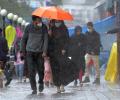
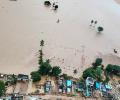
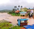
As heavy rains batter several parts of west and south India, the meteorological department on Friday said isolated extremely heavy falls are very likely over Konkan, Goa and central Maharashtra in the next two days.
The country saw 645 events of heavy rainfall and 168 events of very heavy rainfall in November, the highest in the month in five years, the India meteorological department said on Wednesday.

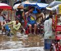
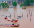
Amid the heavy downpour in Bengaluru, residents of many flood-affected areas have taken to social media to pour out their woes ranging from waterlogging to complaining about "crumbling" infrastructure.

The IMD has predicted heavy rainfall over Karnataka and Kerala for the next few days.

June 1 is the official onset date of monsoon in India when it hits Kerala.

The slow progress of the south-west monsoon has led to overall deficiency of rains by 22 per cent over the last fortnight, the meteorological department on Wednesday said.
The intensity of rainfall is likely to increase with the likelihood of very heavy falls at a few places and extremely heavy falls at isolated places on May 15, reports Sanjeeb Mukherjee.

The southwest monsoon season concluded on Saturday with India receiving 'below-average' cumulative rainfall -- 820 mm compared to the long-period average of 868.6 mm -- in an El Nino year.
Twelve of the 36 meteorological subdivisions recorded deficient rainfall, while the rest witnessed normal to excess rain. In total, 38 per cent of the 662 districts received below-normal rain.

An IMD bulletin said the low pressure area could intensify into a cyclonic storm, triggering heavy to very heavy rainfall in several parts of Kerala.

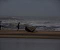
Southwest monsoon hit Kerala on Friday marking the start of the rainy season, four days after its normal onset date.

The cyclonic depression may have crossed the Tamil Nadu coast on Thursday evening, but the state continues to be battered by heavy rains.
'The first two months of monsoon are not looking good.' 'In case both the halves fail, it is going to be misery.'
According to the Karnataka State Natural Disaster Monitoring Centre, there would be heavy rain for the next 24 hours in coastal areas, in the northern and in the interior parts of the south.

Assocham-Skymet report says untimely rain may reappear in north India.

Thunderstorms and dust storms are 'very likely' on Tuesday too, the weather office warned.

The Army, the National Disaster Response Force, police and the fire force along with the locals began rescue operations on Sunday morning at Koottickal and Kokkayar panchayats where over a dozen people are listed to be missing due to numerous landslides accompanied by heavy downpour since Saturday.
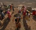
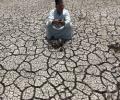
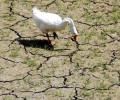
Many farmers in drought hit states are seeking MGNREGA work but the state government's coffers do not have enough fund to pay the salaries of these workers.

22 bodies, 13 from Kottayam district and 9 from Idukki were recovered from various rain-hit areas while National Disaster Response Force teams continued their rescue operations.

They just wanted their angst noticed, and as a symbol of recognition, Jallikattu, restored without the annual ritual of court cases and adjournments, explains N Sathya Moorthy.

Mohapatra said there is a 40 per cent chance of a normal rainfall, 22 per cent above normal, 12 per cent excess and 18 per cent below normal.

The national capital battled weather conditions in the "red category" as the maximum temperature recorded at the Palam observatory was 46.1C,

The sky turned cloudy around 4:30pm and gusty winds swept the national capital.
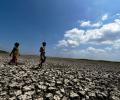
India now faced a higher likelihood of a drought in some parts, as monsoon rain would be less than predicted in April, private weather forecaster Skymet said on Friday.

In another forecast for August, IMD Director General Mrutunjay Mohapatra said monsoon is also likely to be normal in the month.
The India meteorological department has stated that day temperatures are likely to be above normal by 0.5 degree Celsius, reports Sanjeeb Mukherjee.
In the first of a two-part series, Business Standard examines the impact of the upcoming summer on agriculture and drinking water supply.